

Wigwam Hill Loop
Climbs to the foundation of the 1930s Wigwam Hill fire tower with long views toward the Blackstone Valley. Returns past the Taft cellar hole and a documented section of the Nipmuc Path.
Elevation profile
What you might spot
 Plant
PlantPink Lady's Slipper
Cypripedium acaule
Solitary pink “moccasin” flower on a leafless stalk; two broad basal leaves often visible. Massachusetts native orchid — illegal to pick or dig; photograph only.
Late May through mid-June (peak around Mendon Memorial Day week)
📍 Mendon Town Forest — acidic pine–oak understory along the Wigwam Hill loop and side spurs.
 Plant
PlantMountain Laurel
Kalmia latifolia
Evergreen-looking shrubs with smooth, oval leaves in whorls; late spring clusters of pink-and-white cup flowers. Common on Worcester County uplands — blooms slightly earlier in sunnier openings.
Late May through June along Mendon ridgelines
📍 Mendon Town Forest — sunny pockets and rocky knobs on Wigwam Hill and connecting ridges.
 Wildlife
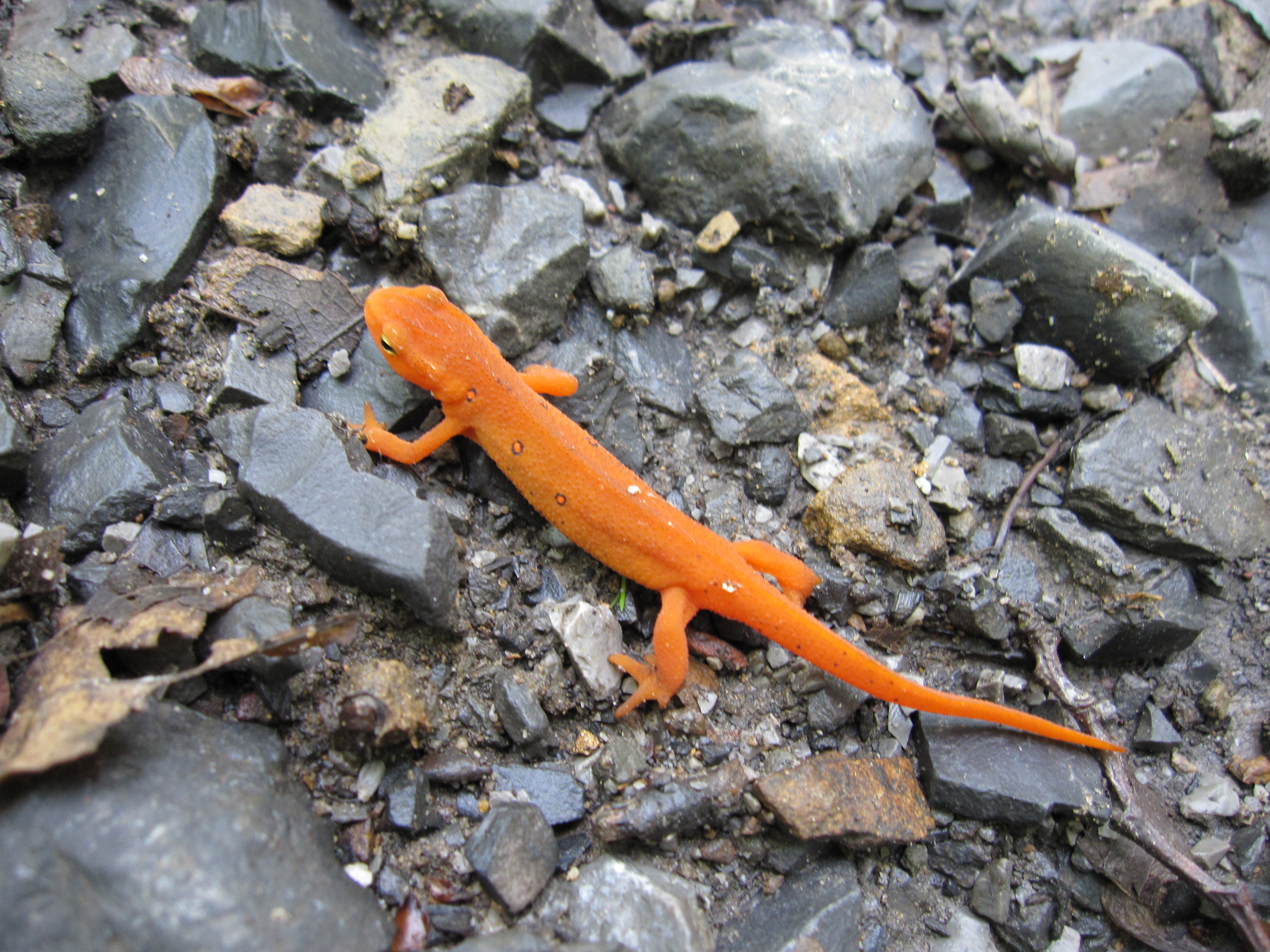
Eastern Newt (red eft)
Notophthalmus viridescens
Terrestrial “red eft” stage: bright orange-red with darker-bordered spots — slow-moving on trails after rain. Do not handle; oils on skin can harm amphibians.
Efts common April–October; adults in pools early spring
📍 Meadow Brook corridor — kettle topography and seasonal wetlands support pool-breeding amphibians.
 Fungi
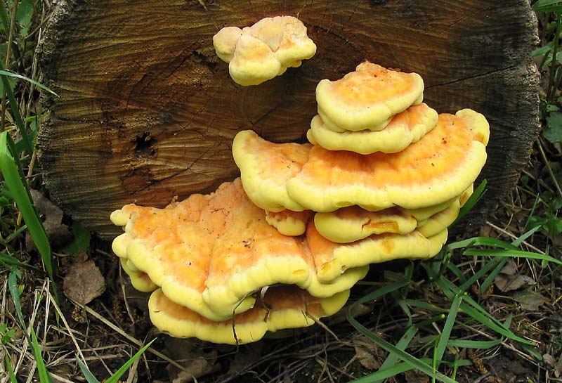
FungiChicken of the Woods
Laetiporus sulphureus
Overlapping orange shelves with sulfur-yellow pore surface underneath. Always confirm ID with a trusted guide — some look-alikes cause GI distress.
Typically August through October after humid Mendon summers
📍 Cormier Woods — mature oak and hemlock stands with abundant coarse woody debris.
 Plant
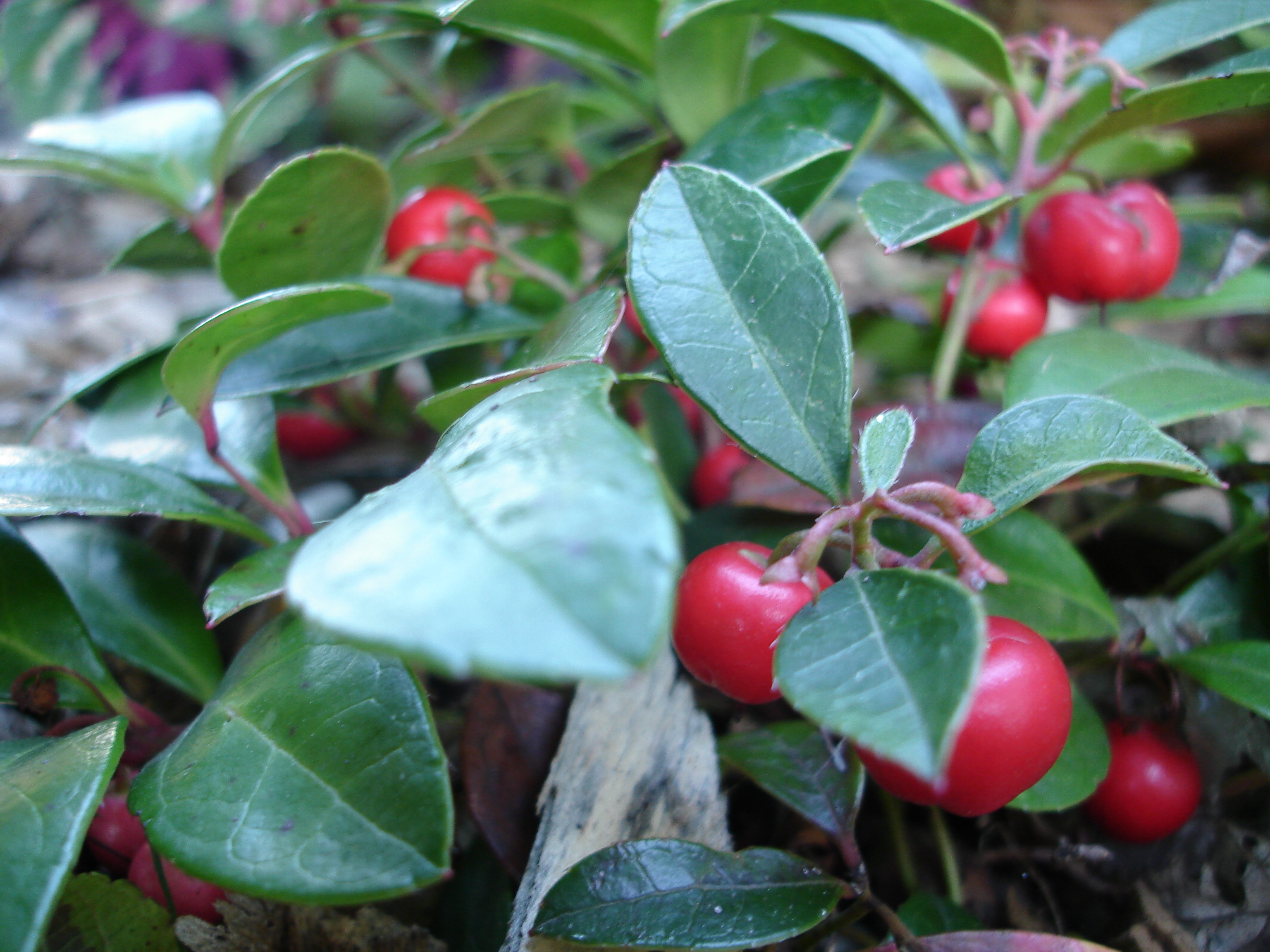
PlantWintergreen
Gaultheria procumbens
Low creeping groundcover with thick, glossy evergreen leaves and bright red berries persisting through winter. Crush a leaf for a distinctive wintergreen (methyl salicylate) scent — unmistakable. Tiny white urn-shaped flowers appear in July.
Year-round (berries most visible October through early spring under snow)
📍 Mendon Town Forest — among the most reliable groundcover species on the Wigwam Hill and Anchor Rock trails; look between pine roots and along sandy ridgetop sections.
 Plant
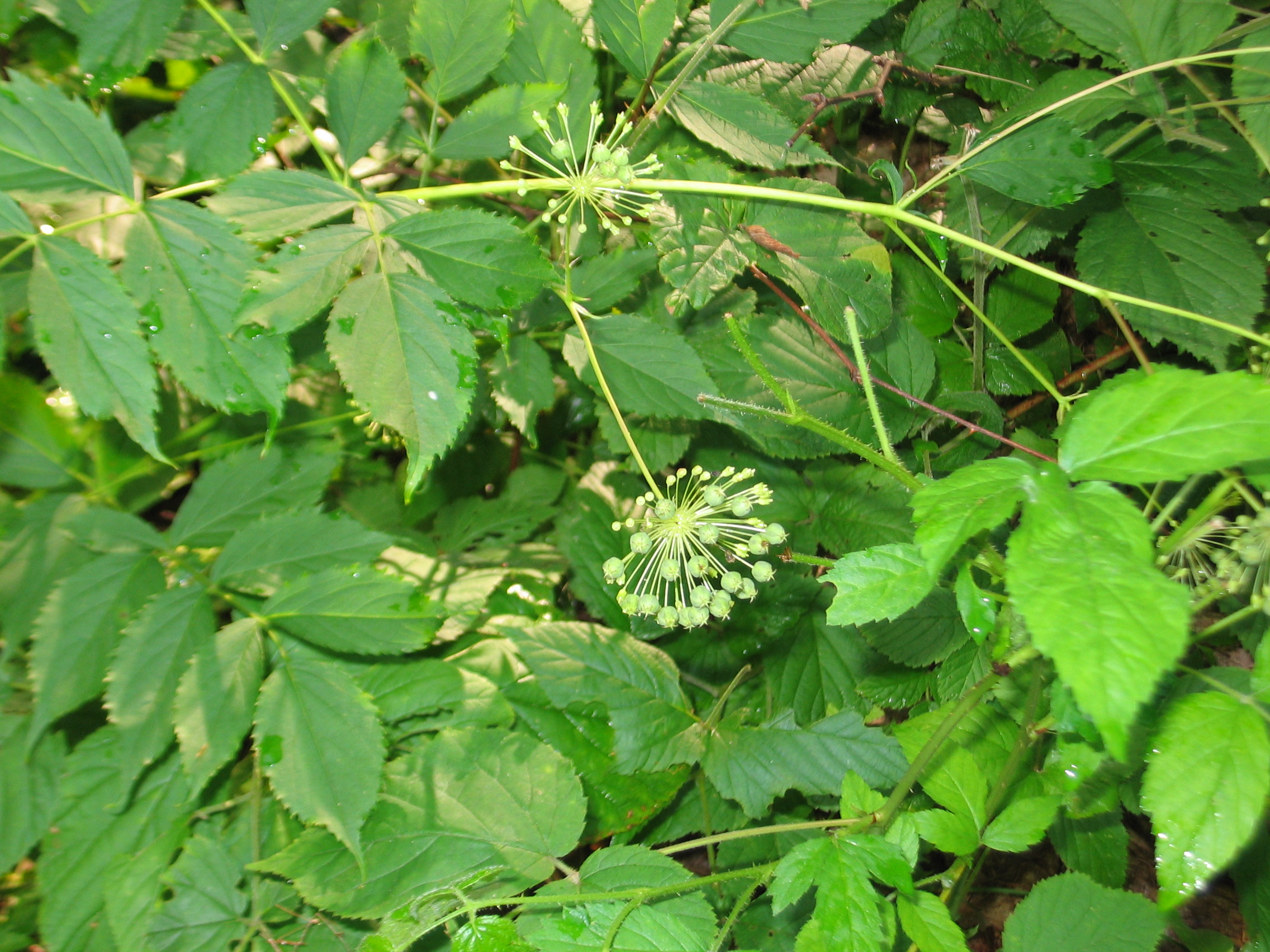
PlantWild Sarsaparilla
Aralia nudicaulis
Single compound leaf on a long stalk, divided into three groups of five leaflets — easy to mistake for a small tree seedling. A separate leafless stalk bears spherical clusters of tiny white flowers in June, followed by dark purple berries. Roots historically used as a sassafras substitute.
Leaves emerge May; flowers June; berries ripen August
📍 Mendon Town Forest — one of the most common herbaceous plants along the Anchor Rock Trail; look for the distinctive single-leaf-with-separate-flower-stalk combination.
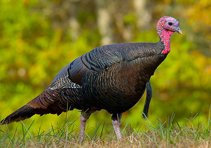 Wildlife
Wild Turkey
Meleagris gallopavo
Large, dark, iridescent bird with a bare red-and-blue head; males display fan-shaped tails and prominent beards. Flocks scratch loudly in leaf litter. Often heard before seen; males gobble from roost trees at dawn in spring.
Year-round; gobbling and strutting displays March–May; poults visible June–July
📍 Mendon Town Forest — flocks forage in the oak understory along the Wigwam Hill trails year-round; the dawn gobbling carries clearly from ridgetop roosts.
 Wildlife
Ovenbird
Seiurus aurocapilla
Warbler-sized but walks on the ground like a thrush; olive-brown back, streaked breast, and orange crown stripe bordered by black. The call — a ringing, escalating “teacher-teacher-TEACHER” — carries through the forest all summer and is far more often heard than the bird is seen.
Arrives early May; sings through July; departs by September
📍 Mendon Town Forest — one of the most abundant breeding birds in the interior oak forest along Wigwam Hill; the loud, repetitive call is nearly constant on summer mornings.
 Wildlife
Eastern Box Turtle
Terrapene carolina
High-domed shell with variable orange and yellow markings on brown or black background; hinged plastron allows it to close completely. Moves slowly; often found near berry patches. Massachusetts Species of Special Concern — do not relocate if found on a trail.
Active May through September; most often encountered after summer rain
📍 Mendon Town Forest — dry upland areas away from the wetland trails; most likely to be found in drier oak sections on summer mornings after rain.
 Fungi
FungiTurkey Tail
Trametes versicolor
Thin, leathery, multi-colored concentric zones — tan, brown, rust, gray — fan out like a turkey's tail. The pore surface underneath is white or cream with tiny pores (not gills) — the critical check against look-alikes. One of the most common bracket fungi in New England and a good entry point for beginning foragers.
Year-round on downed wood; fruiting bodies persist through winter
📍 Cormier Woods — abundant on downed hardwood throughout the trail system; nearly every large decaying log has at least one colony.
 Fungi
FungiHen of the Woods (Maitake)
Grifola frondosa
Large, overlapping rosette of gray-brown, fan-shaped fronds arising from a single base; white pore surface underneath. Can reach 30+ lbs. Grows reliably at the same oak's base year after year. Among the most sought-after edible fungi in Massachusetts — always confirm ID before consuming.
Late September through October; earlier fruiting in wet years
📍 Mendon Town Forest — mature oaks along the Wigwam Hill and Anchor Rock trail systems; look at the base of large-diameter oaks in late September.
History in this area
Squinshepauke Deed and Founding Ground
1662The original land purchase for what became Mendon: a 1662 deed signed with Nipmuc leaders Great John and Quashaamit for twenty-four pounds sterling.
Albee's Grist Mill and King Philip's War
1664Benjamin Albee's 1664 grist mill became an early industrial landmark, then a flashpoint when warfare reached Mendon in 1675.
Incorporation and Mother Mendon
1667Mendon incorporated on May 15, 1667 and later gave rise to eight municipalities across two generations, earning the nickname Mother Mendon.
Wigwam Hill Fire Tower Site
1937CCC-era steel fire tower foundation atop Mendon's highest point. Decommissioned in 1971; concrete piers and anchor bolts remain.
Guided hike
Wigwam Heritage Route
A short historical sequence that links Indigenous landscape context, Taft-era settlement traces, and the CCC fire-tower era on Wigwam Hill.
Read the 3-stop guide →Permitted uses
Hunting permitted in season; no hunting on Sundays (Massachusetts General Laws ch. 131 § 57). No motorized vehicles or ATVs. Horses welcome on the wider forest roads. Cyclists should yield to all other users.
Surfaces
Accessibility
Max grade
12%
Firm surface
30%
Steeper and root-heavy in several sections; best for steady hikers and trail runners.
History
Wigwam Hill is Mendon's highest point at approximately 560 feet and the cultural heart of the Town Forest. The summit fire tower was erected in 1937 by the Civilian Conservation Corps (CCC) as part of the Massachusetts Department of Conservation's statewide aerial-fire detection network. Standing 60 feet on a lattice-steel frame, the tower was staffed seasonally by state fire wardens who logged smoke sightings across the Blackstone Valley. It was decommissioned around 1971 when airborne patrol aircraft replaced the ground network; the concrete pad, anchor bolts, and a rusted steel leg remain visible in the clearing today.
The hill's name predates the tower. Eighteenth-century Mendon deeds reference "Wigwam Hill" in relation to a documented Nipmuc encampment and travel corridor. The Nipmuc people inhabited the Blackstone River watershed for thousands of years before English settlement; portions of the trail follow ridgelines that align with surveyed sections of the historic Nipmuc Path connecting Quinsigamond and Wenakeag.
At the forest's eastern edge, the Taft cellar hole marks the site of the 1800s homestead of the Taft family, early Mendon settlers whose descendants gave their name to several local landmarks. Fieldstone foundation walls and an ornamental granite doorstep survive in the leaf litter. A nearby stone wall network dates to the same era and once divided the Taft woodlot from the open agricultural fields that surrounded it.
The Dance Hall foundation—a poured-concrete floor with partial wall footings—can be found along the southern spur. Local oral history holds that it was an informal recreation structure built in the early 20th century for seasonal dances attended by residents of the surrounding farms; the building is long gone but the floor endures.
Trailheads & parking
Tower Rd / Millville access
Parking available
Town listing: eastern lot on Millville Rd (main summer parking); southern kiosk 99 Tower Rd; western kiosk 6 Southwick St; parking is limited at Tower Rd and Asylum St. Brewer Trail easement connects toward Meadow Brook / Cormier near 41 Asylum St. Use the official PDF map for current routes.