
The Mendon you walk through.
Founded 1667 · 350+ years of recorded history · 15 places tied to trails you can walk.
From Nipmuc travel routes to King Philip's War, George Washington's post-road journey, Lydia Chapin Taft's landmark vote, and Aerosmith's first concert — the places we hike are layered with story.
Mother Mendon gave rise to eight towns and once held an original copy of the Declaration of Independence in its town vault. See the Town of Mendon History page and the Historical Commission.
Before contact
Nipmuc Trail Overlook
Section of the historic Nipmuc Path connecting Quinsigamond and Wenakeag — a traditional travel and trade route through the Blackstone uplands.
The Nipmuc people lived throughout central Massachusetts for thousands of years before European contact. Several Mendon trails — including portions of the Wigwam Hill loop — follow ridgelines that align with documented sections of the Nipmuc Path.
Featured in
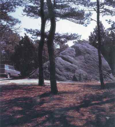
Rock Ledges
Prominent geological rock ledges exposed by glacial activity.
These steep, exposed ledges in Cormier Woods offer scenic interest and a look at the underlying bedrock geology of the region.
Featured in
 Paul Revere, 1772 — Wikimedia Commons (public domain)
Squinshepauke Deed and Founding Ground
The original land purchase for what became Mendon: a 1662 deed signed with Nipmuc leaders Great John and Quashaamit for twenty-four pounds sterling.
The Nipmuc people — whose name means "small pond place" or "people of the fresh waters" — inhabited central Massachusetts for thousands of years before contact. Before incorporation, the area was known as Squinshepauke Plantation. On September 8, 1662, sachem Great John set his hand and seal to the deed, conveying the land for twenty-four pounds sterling. Two Praying Indian villages existed within the original grant, underscoring the layered and contested beginnings of Mendon's colonial era.
Colonial Mendon (1660–1800)
Taft Main House
The main homestead site of the Taft family in the Town Forest area.
The Taft Main House marks the residential center of the Taft family's historic landholdings, which form a significant portion of today's Town Forest.
Featured in
Jonathan White Homestead Ruins
The stone foundation ruins of the Jonathan White homestead in Cormier Woods.
These ruins reflect the agricultural history of the Cormier Woods parcel, showcasing classic New England fieldstone cellar hole construction.
Featured in
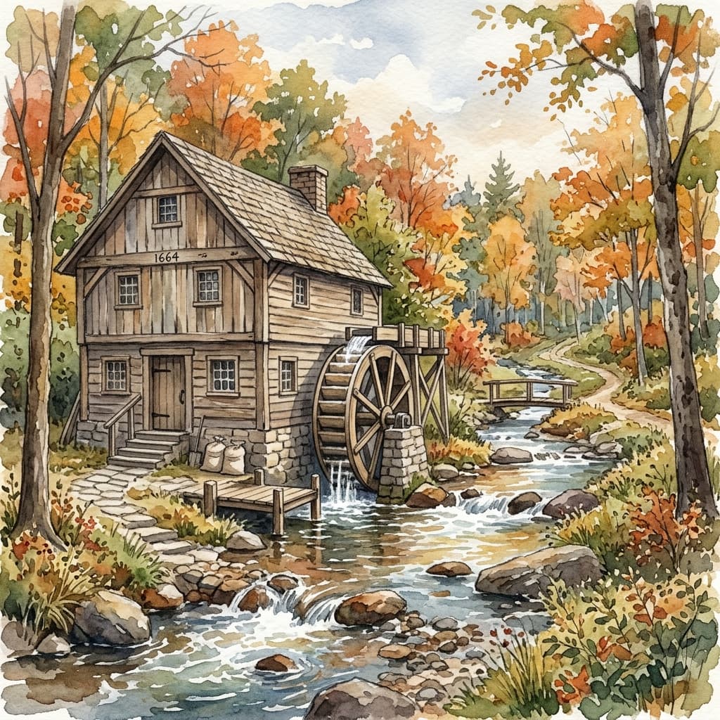
Albee's Grist Mill and King Philip's War
Benjamin Albee's 1664 grist mill became an early industrial landmark, then a flashpoint when warfare reached Mendon in 1675.
Albee's mill is cited as the first water-powered grist mill in the immediate region. On July 14, 1675, Nipmuc warriors led by Matoonas fell upon colonists working in a field — historians record it as the first settler blood shed in King Philip's War within the Massachusetts Bay Colony. By February 1676, Indians had burned all the dwellings and the meeting house; twelve years of settlement were swept away in hours. Matoonas was later bound to a tree on Boston Common and shot by men of his own tribe as war's price. Resettlement began by 1678–1680, shaping the rebuilt community that followed.
Featured in
Incorporation and Mother Mendon
Mendon incorporated on May 15, 1667 and later gave rise to eight municipalities across two generations, earning the nickname Mother Mendon.
The original grant covered roughly 64 square miles. Five towns split directly from Mendon: Bellingham (1719), Uxbridge (1727), Upton (1735), Milford (1780), and Blackstone (1845). Three more — Northbridge (from Uxbridge, 1742), Hopedale (from Milford, 1886), and Millville (from Blackstone, 1916) — were carved from those first-generation daughters. All eight together trace their civic origins back to Mendon's original grant. The 1845 separation of Blackstone alone stripped two-thirds of Mendon's population and half its tax valuation overnight. Even after those splits, Mendon retained a distinct rural landscape of stone walls, farms, and woodland routes now reflected in today's open-space trail network.
 CC BY-SA 4.0 Matthias Nonnenmacher — Wikimedia Commons
Old Cemetery (Established 1669)
One of Mendon's oldest civic sites, with graves of forty Revolutionary War soldiers.
The Old Cemetery marks the continuity of the resettled town and its civic memory. Local-history sources note forty Revolutionary War soldier burials there, making it one of Mendon's strongest surviving links between colonial settlement and the Revolutionary period.
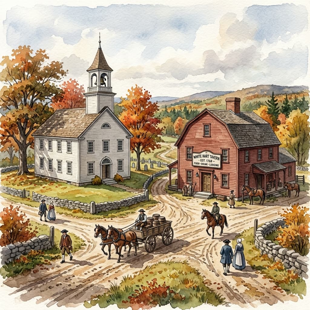
Mendon Meetinghouse and Tavern District
The 1769 meetinghouse served as worship space, town hall, and civic center, near the 1745 Ammidon Tavern.
In colonial New England, meetinghouses doubled as governmental infrastructure. Mendon's 1769 building anchored religious life, town meetings, and community decisions in one place, while nearby tavern activity supported travelers and local commerce along established cart-road routes.
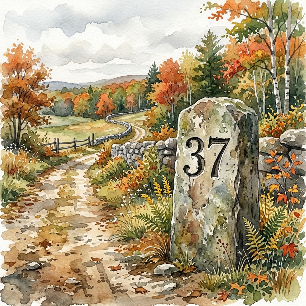
Boston Post Road Milestone (1772)
A surviving milestone marked "37 miles from Boston," now preserved in Founders' Park as a reminder of Mendon's colonial road network.
The 1772 stone — Milestone 37 from Boston along the Boston Middle Post Road — connected Mendon to the travel corridor along Hartford Pike and the broader post-road era. Its survival in Founders' Park is a rare physical marker of the same transportation routes that linked farm lots, taverns, and town meeting life across colonial Mendon.
Mendon Resolves and Lydia Chapin Taft
Mendon's 1773 resolves articulated natural rights language echoed in 1776, and local-born Lydia Chapin Taft is recognized as America's first woman legal voter.
On March 1, 1773, Joseph Dorr presented nineteen resolves after a Boston Committee of Correspondence letter reached town meeting, asserting that government must rest on consent and rights to life, liberty, and property. Historians note this phrasing closely precedes language in the Declaration of Independence. The same local historical lineage includes Lydia Chapin Taft of Mendon, who legally voted in Uxbridge in 1756 under a property-tax principle.
 Mendon Historical Society — 1907 Town Report
Washington Turned Away (1789)
During his post-inauguration tour of New England, President George Washington was reportedly denied lodging in Mendon by an innkeeper's wife — a small footnote on the same post road that shaped the town.
Washington traveled the Boston–Hartford post road through central Massachusetts in the autumn of 1789. Local tradition holds that an innkeeper's wife in Mendon turned away the newly inaugurated President when he sought a room. Whether the story is strictly true or embellished over time, it testifies to how thoroughly Mendon lay astride one of colonial New England's main arteries — the same road whose 1772 milestone still stands in Founders' Park today.
Industrial & resort era (1800–1940)
Taft Mill
Historic mill site within the Mendon Town Forest along the watercourse.
Noted on the Town Forest map, the Taft Mill represents Mendon's early industrial efforts utilizing local water power.
Featured in
Dance Hall / Grist Mill
A dual-purpose historic structure site offering social and industrial value to early Mendon.
Located in the Town Forest, this site served as both a grist mill and a community dance hall, highlighting the blend of commerce and social life in the rural landscape.
Featured in
 Mendon Historical Society Digital Archive
The Gaskill Family and Gaskill Meadows
The Gaskill family were prominent Mendon landowners whose fields and wetlands along the Lake Nipmuc shoreline are now conserved as Gaskill Meadows Conservation Area.
Leonard Gaskill and his family held farmland near the Lake Nipmuc shoreline through the late nineteenth and early twentieth centuries — a period when the lake itself drew resort visitors by the hundreds. The open meadows, impoundments, and wetland edges that bear the Gaskill name today are managed by the Mendon Conservation Commission. The shallow impoundments here attract painted turtles, great blue herons, and migratory waterfowl, making what was once private farmland one of the most reliably productive wildlife-watching spots in town.
 USGS — Wikimedia Commons (public domain)
Taft / Anchor Rock
A large granite glacial erratic in the Mendon Town Forest featuring an 1876 chiseled carving of an anchor and the initials J.F. Taft.
Rather than a maritime artifact, Anchor Rock gets its name from a large, deliberate carving chiseled into its surface. The rock bears the image of an anchor alongside the initials 'J.F. Taft' and the date 'April 28, 1876.' According to the Taft Family Association, J.F. Taft likely owned a sawmill in what is now the Town Forest, making this stone a lasting, personalized boundary or landmark from Mendon's late 19th-century industrial-agricultural period.
Featured in

Lake Nipmuc Park Resort (1900s)
In the early twentieth century, Lake Nipmuc was a popular summer resort drawing visitors with 'leading musical and vaudeville talent' — a very different scene from the quiet wetlands hikers encounter today.
The glacially carved kettle pond now known as Lake Nipmuc was once the centerpiece of a commercial resort, Lake Nipmuc Park, that drew crowds from across the region. Steamboats, pavilions, and summer entertainment were routine at a time when working-class New Englanders flocked to lakeside parks by streetcar and rail. Among the performers was Fannie Usher, a vaudeville actress who appeared at the Lake Nipmuc summer theatre with her brother Claud and their dog Spare Ribs. That era ended as automobile tourism reshaped recreation; the lake has been quiet ever since, managed today through the Lake Nipmuc Task Force for water quality and open-space protection.
- Lake Nipmuc Task Force — Town of Mendon
- Mendon, Massachusetts — Wikipedia
- Mendon Historical Society Digital Archive
20th century to today
 CC0 — Wikimedia Commons
LAND, CPA, and the trail network you walk
How state and local programs helped stitch together the interconnected preserves the Town lists today.
The Town's passive-recreation overview credits the Massachusetts LAND Grant Program, Mendon's Community Preservation Act, donations, and thousands of volunteer hours alongside work by the Town, The Trustees of Reservations, Metacomet Land Trust, MassWildlife, and private landowners. That collaboration is how many of the parcels—from Mendon Town Forest to Meadow Brook and Cormier—stay permanently protected and open for careful public use.
Historic Cabin
A rustic cabin situated within Cormier Woods.
This cabin is a notable landmark on the Trustees' Cormier Woods property, providing a glimpse into mid-century woodland retreats.
Featured in
 CC BY-SA 4.0 — Wikimedia Commons
Wigwam Hill Fire Tower Site
CCC-era steel fire tower foundation atop Mendon's highest point. Decommissioned in 1971; concrete piers and anchor bolts remain.
Built by the Civilian Conservation Corps in 1937 as part of the statewide forest-fire detection network, the Wigwam Hill tower stood 60 feet tall and remained in seasonal use through the late 1960s. The hill itself takes its name from a documented Nipmuc encampment area noted in 18th-century deeds.
Featured in
Aerosmith's First Concert (1970)
On November 6, 1970, Aerosmith played their first-ever concert at Nipmuc Regional High School in Mendon — before the band had a record deal or a national following.
The same community that incorporated in 1667 and watched its earliest settlement burn during King Philip's War hosted one of rock's most celebrated debut performances three centuries later. The Nipmuc Regional School District building stood less than a mile from the same town center that had been built, destroyed, and rebuilt in the 1600s. The fact is well enough documented to appear in rock history timelines — an unlikely but entirely genuine footnote to Mendon's long story.
 CC BY 2.0 Uxbridge Caddie — Wikimedia Commons
Blackstone Heritage Corridor Era
Mendon's inclusion in the Blackstone River Valley National Heritage Corridor connected local conservation to a wider regional preservation strategy.
When the corridor was designated in 1986, Mendon's landscapes were framed as part of a larger Blackstone Valley story linking industry, agriculture, and upland ecology. That regional lens supports the modern partnership model visible today: town stewardship, CPA funding, land trusts, and state wildlife managers keeping connected preserves open for careful public use.